Google Earth

MasterBlaster

Administrator Emeritus
Joined
Mar 6, 2005
Messages
97,564
Location
Louisiana!
It's an amazing application. I just checked out the military base I was stationed at 30 years ago, and I could see the barracks I was living in, even the chow hall.

I try to visit any place in my life where I can remember an address, orrrr whatnot. It's amazing what you can see.

Waycool, if I do say so myself!

 
I use it daily. People at work are constantly amazed at how useful, and novel, it is.

I use the zip code maps a lot around here. There are so many layers that are fun to explore!

love
nick
 
First time I was on it I checked out Rex Lane in Corpus Christi where I lived in '74.....actually, it's a neighborhood called Flour Bluff. Cool to put a bit of flesh on memories.
 
We use it here at the Naval Air Station to aid our Search and Rescue missions. We just used it tonight to print out an area for our helicopter to land in the Olympic Mountains. It comes in hamdy as a backup to our SAR mapping system.

Pretty cool application. I have done what Butch has too... looked at a lot of places I have been... Hey Butch, check out Olongopo P.I.! The shit-river bridge is still there... and you can follow Magsai-sai Blvd. all the way to the turnaround. However... it looks like it is all going industrial around where the base used to be. Don't look nothin' like it did in '87!:( The runways and hangars are still at the old NAS Cubi Pt.

Gary
 
does'nt google earth come in two versions? One is free and the other you pay for?
the free one focuses about, I dont know maybe 2,000 feet?
I heard you can buy a version that focuses closer
 
There is www.maps.google.com which is web based. You don't download anything.

Then there is the free google earth which you download onto your computer. Then there is google earth PLUS which you pay for, which uses the SAME maps, same resolution as the other 2. You are paying for OTHER options that come along with the map like the ability to upload GPS coordinates straight from the GPS and the ability to PRINT in higher resolution. Plus costs $20. There is also google earth PRO that is $400!!!! It lets you do other stuff that I don't relate to the PRO...it looks like something that a Realtor would appreciate.

I've not heard of a version that would allow you to focus closer. I'd pay for it. I NEED to know how many shingles on top of my apartment!

love
nick
 
We use it here at the Naval Air Station to aid our Search and Rescue missions. We just used it tonight to print out an area for our helicopter to land in the Olympic Mountains. It comes in hamdy as a backup to our SAR mapping system.

Yeah, we were like, "Oh go ahead and throw those Navy boys a bone! Let them take this one."

:P

Actually my EO was pissed we didn't launch on that one, but the A.C. declined that one for an overdue boat. Doh!

But for Google Earth, yeah, it's cool as hell. I use it for looking at rivers, beaches and such for fishing. It's amazing if'n you ask me. :thumbup:
 
In some cases you can select "street view' get 360° street level photographic views. They're driving around in specially equipped vans photographing whole cities.

Google trivia:
There's one location in San Jose where the image clearly shows a guy on a bench picking his nose.

Go to Google, then click on 'Maps' in the upper left corner of the page.
Then, plug this address into the search bar and click the 'Seach Maps' button.

181 W San Carlos St, San Jose, Santa Clara, California 95113, United States

Now click 'Street View' at the top right of the map; there will be a little yellow man symbol, click it but don't move it. You'll see a guy on a bench, zoom in on him.
 
Yeah, good for that too! Alot of the area where I hunt hasn't been scanned or photoed or whatever, to a level of high enough resolution to show details that indepth.
 
I was playing with it today, Google Earth that is. I like the photos that people have attached to places. Its also fun to look for beeched and sunken ships from WW2.
 
Hawaii for one thing. Find the Pearl Harbor Monument.

You can see the U.S.S Utah and U.S.S. Arizona's turret and the monument on top of it. Its cool looking around Pearl Harbor. I am trying to remember another pacific battle were a lot of ships sunk in shallow waters.
 
I just got the joystick control and loaded the software. It's a pretty sensitive device and getting smooth with it is going to take a little time. But in the hour or so I played around with the device it became intuitive and I wasn't thinking so much about it. I do like it. Sure beats the key board on this laptop.
 
  • Thread Starter Thread Starter
  • #21
That's pretty cool. I just uploaded the newest virgin of GE and it's much improved. I was flying over the 9th ward in New Orleans and you can still see the devastation.
 
I use it to check out the land lay on properties i want to buy all the time. It so awesome for finding hills and such with a view.
 
  • Thread Starter Thread Starter
  • #23
I just checked out the roof of the house where my family lived in japan, 40 years ago. It's amazing they're still standing. My grade school in wichita falls is still there, also.
 
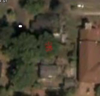
I just used it to figure out the radius the crane will work at so I'll know what crane to bid for, before the crane guy gets back to me 8)

White circle is about where the crane will be, red spray marks the tree:
Conner.jpg
 
One of my Kayaking trips. My Garmin GPS unit will link with Google earth to give me these neat pictures........ pretty awesome. The second picture was from a trip in Maine
 
Back
Top